When a design team starts work from outdated mapping, rough dimensions or assumptions made on a site visit, problems tend to surface later – usually when changes are more expensive to make. A topographical land survey gives architects, engineers, contractors and developers a reliable measured record of existing site conditions, so decisions are based on evidence rather than guesswork.
For commercial projects, residential schemes and infrastructure work alike, that measured baseline matters. Levels, boundaries, buildings, kerbs, drainage features, services evidence, vegetation, walls and access points all influence how a site can be designed, costed and built. If the survey data is incomplete, every downstream stage carries more risk.
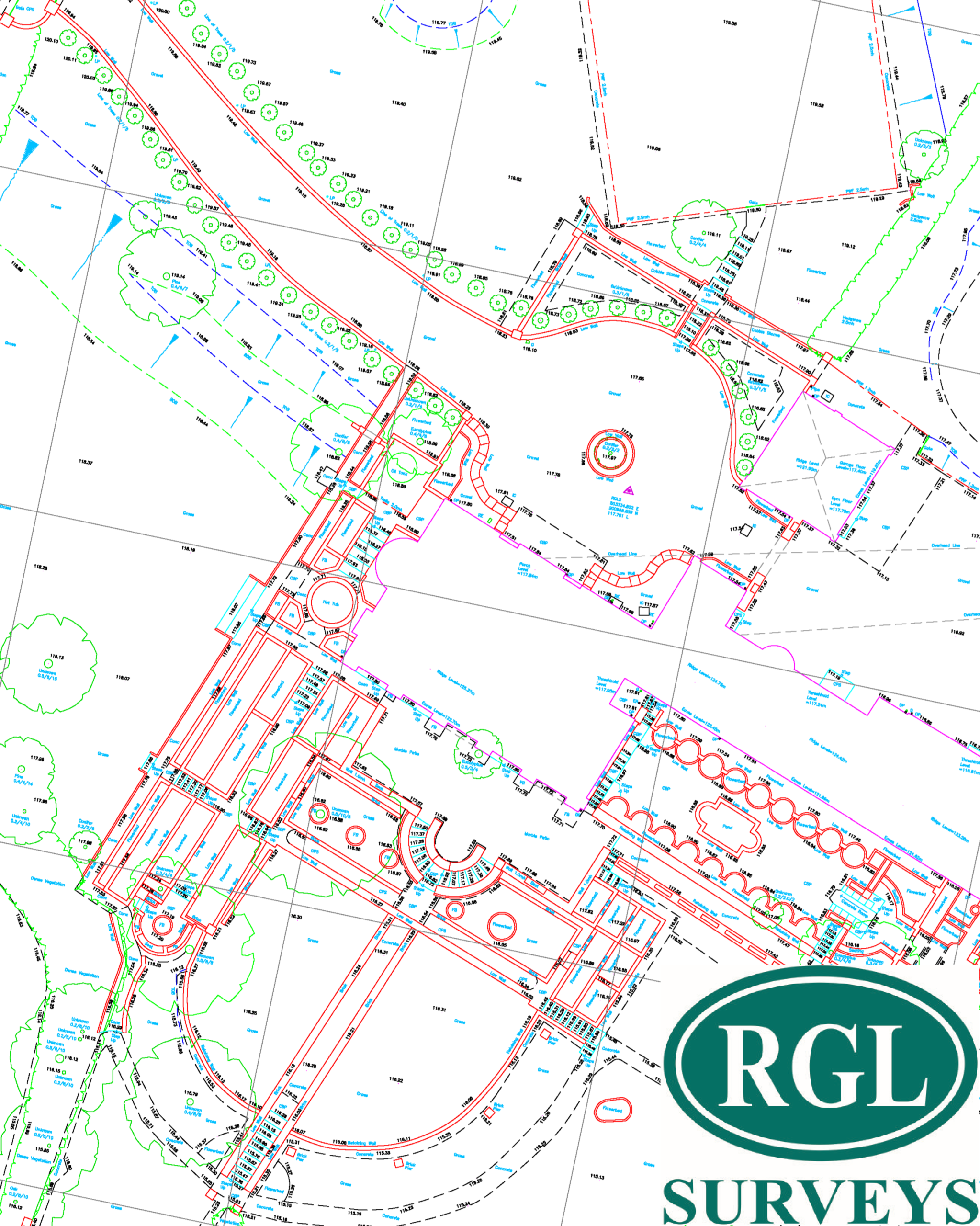
What a topographical land survey is
A topographical land survey is a detailed measured survey of the physical features and levels across a site. Its purpose is to capture what is there, where it is, and how it relates spatially to the surrounding land and built environment.
The output is usually provided as a 2D drawing, and where required as 3D model data, point clouds or coordinated survey information suitable for design teams. The exact scope depends on the project brief. A small infill plot in an urban setting will need a different level of detail from a large development site, highway corridor or operational commercial premises.
In practice, the survey becomes the reference base for planning submissions, concept design, detailed design, earthworks assessment, drainage strategy, setting out preparation and construction coordination. It is not simply a plan showing a few spot levels. A properly specified survey is a working technical document that other disciplines rely on.
What the survey normally includes
The content of a topographical land survey is driven by project need, but there are core features that are commonly measured. These usually include site boundaries, existing buildings, finished floor levels where visible and relevant, walls, fences, kerb lines, road markings, footways, inspection covers, gullies, service boxes, banks, ditches, trees, changes in level and other fixed features that affect design or construction.
Level information is one of the most valuable elements. Spot heights, contours and break lines help the design team understand site fall, drainage behaviour and earthworks implications. On some projects, subtle level changes are more important than prominent visible features. A site may look straightforward until accurate survey data shows restricted falls, threshold conflicts or retaining requirements.
Feature coding and layering also matter. Good survey data should be structured clearly so architects, engineers and planners can use it efficiently. If the drawing is difficult to interpret or inconsistent in presentation, the value of the fieldwork is undermined.
Why accuracy matters early
Most project teams understand that a survey should be accurate, but the commercial impact of accuracy is often underestimated. Early-stage errors rarely stay small. A misplaced boundary line, omitted retaining edge or poor level control can affect planning layouts, cut and fill assumptions, utility routes, access design and buildability reviews.
The right survey at the start reduces redesign and helps avoid site-based surprises. That does not mean every project requires the highest possible survey specification. It means the level of detail and control should match the decisions the data will support. There is always a balance between programme, cost and scope, but under-specifying a survey often creates false economy.
This is particularly relevant on constrained sites, live operational environments and locations with complex interfaces between existing structures and external works. In those cases, a survey needs to do more than record visible lines on the ground. It needs to support coordinated design with enough precision for confident decision-making.
Topographical land survey data and project risk
A topographical land survey is one of the first opportunities to reduce technical risk on a project. It helps establish constraints before design work becomes fixed and before procurement decisions are made on unreliable assumptions.
For planners, it clarifies existing site conditions and context. For architects, it informs layout, access, massing and threshold relationships. For civil engineers, it supports drainage design, external works and levels strategy. For contractors, it provides a better basis for logistics planning and construction sequencing.
There are limits, of course. A topographical survey does not by itself confirm legal ownership, underground utility positions or structural condition. It can show service covers and visible indicators, but if buried utilities are a design or safety issue, utility detection may also be required. Likewise, if a project depends on accurate building geometry, a measured building survey may need to sit alongside the topographical work.
That is why the brief matters. The survey should be specified as part of a wider technical requirement, not treated as a generic tick-box exercise.
How survey scope should be defined
A useful survey brief is specific about what the design team needs to receive. Site extents are the starting point, but they are not the whole story. Adjoining highways, neighbouring structures, access routes, embankments or off-site features may need to be included if they influence planning, drainage, visibility or construction methodology.
Required outputs should also be agreed at the outset. Some clients need a clear 2D drawing for planning and concept work. Others require coordinated digital data for multidisciplinary design environments. On engineering-led projects, grid control, benchmarks and level datum information are critical. On phased developments, survey control that supports later setting out can add real value.
Timescale is another consideration. Fast mobilisation is often important, especially where land acquisition, planning submissions or live programme decisions depend on measured information. Even so, speed should not come at the expense of completeness. A prompt survey is only useful if the resulting data can be trusted.
Technology is important, but method matters more
Modern instruments have transformed survey delivery. Total stations, GNSS equipment, laser scanning and mobile data capture can all improve efficiency and detail when used correctly. For clients, that typically means faster fieldwork, better coverage and outputs that integrate more easily into design workflows.
But equipment alone does not guarantee quality. Survey control, line interpretation, feature coding, data checking and experience on difficult sites are what produce dependable results. Dense point data is not automatically better data if it has not been processed and presented with care.
This is one reason experienced surveyors remain essential on complex projects. Vegetation cover, busy operational sites, restricted access, reflective surfaces, awkward level changes and traffic-sensitive locations all require practical judgement. The best method is the one that captures the right information safely and efficiently for the task at hand.
When a topographical survey needs supporting services
Many projects benefit from combining a topographical land survey with related survey services. If the design extends into an existing building, floor plans, elevations or roof plans may be needed to create a coordinated picture. If excavation, drainage installation or service diversions are planned, utility detection can become equally important.
Volume calculations may also be relevant where stockpiles, landfill profiles or earthworks quantities are part of the commercial picture. Monitoring can be necessary on sites affected by movement risk or adjacent construction activity. The most effective approach is often a tailored survey package rather than a single isolated instruction.
For clients managing varied project types across South East England, the Midlands or London, consistency in survey delivery can be just as useful as technical capability. Standardised outputs, clear communication and dependable turnaround make it easier to move from survey to design without avoidable delay.
What good survey delivery looks like
From a client perspective, good delivery is not complicated. The surveyor understands the brief, asks the right technical questions, attends site promptly, works safely, and provides accurate outputs in the agreed format. Drawings are clear, coordinated and usable. Queries are dealt with quickly. If access issues or scope gaps arise, they are flagged early rather than discovered after issue.
That service discipline matters as much as technical competence. Survey data often sits on the critical path. If it arrives late, lacks required detail or creates uncertainty, the programme impact can spread across multiple consultants and contractors.
RGL Surveys Ltd works on that basis – providing tailored measured survey support that matches project scope, site conditions and programme requirements, whether the requirement is straightforward or technically demanding.
A topographical land survey is rarely the most visible part of a project, but it is often one of the most influential. When the existing site is measured properly, the rest of the team can move forward with greater confidence, fewer assumptions and a much firmer foundation for the work ahead.