A topographic survey usually gets commissioned when a project is already moving and decisions need to be made quickly. At that point, poor site information can slow design, create rework and introduce avoidable cost. If you are planning how to commission a topographic survey, the priority is not simply booking a surveyor. It is defining the right scope, the right outputs and the right level of detail for the decisions ahead.
For architects, engineers, developers and contractors, the quality of the initial survey has a direct effect on design coordination, planning submissions, drainage strategy, setting out and site risk management. A survey that is too limited may need revisiting. A survey that is over-specified can increase cost without adding useful value. Good commissioning is about matching the survey to the project stage and the intended use of the data.
How to commission a topographic survey properly
The starting point is to be clear about why the survey is required. A planning-stage survey for a small development site will not always need the same density of detail as a live construction site with complex boundaries, level changes and below-ground constraints. Before requesting a fee, you should identify who will use the survey and what they need from it.
In most cases, that means confirming whether the survey will support planning, concept design, technical design, construction coordination or ongoing asset management. Each use case affects scope. If an architect is preparing a planning layout, the emphasis may be on boundaries, existing buildings, levels, hardstanding, trees and visible site features. If civil engineering design is the next step, drainage covers, kerb lines, changes in level and service indicators may carry greater importance.
A clear brief avoids assumptions. It also helps the surveyor advise whether the requested scope is sufficient, excessive or missing key elements.
Define the survey area and site limits
One of the most common problems at instruction stage is an unclear survey extent. Clients sometimes refer only to a postal address or a red line boundary from a planning drawing, but the practical site need may be wider. Access routes, adjoining highways, neighbouring structures, retaining walls, verge levels and off-site features can all influence design.
If the survey only covers the ownership boundary and excludes the pavement, carriageway tie-in or surrounding ground levels, the design team may later find they lack the information needed to resolve access, drainage falls or level relationships. It is usually more efficient to agree a sensible working extent at the outset than to mobilise again for a small but critical missing area.
Marked-up plans, aerial extracts and site photographs can all help define this. If there are access restrictions, shared land interests or safety constraints, raise them early.
Identify the features and outputs required
When deciding how to commission a topographic survey, the required outputs matter just as much as the fieldwork. Different consultants use different formats, and the right deliverables should be agreed before work starts.
At a basic level, you should confirm whether you need 2D CAD, PDF drawings, 3D model data, point cloud information, levels related to Ordnance Survey datum, or coordinates tied to the national grid. Some projects only require a standard topographical drawing. Others need georeferenced information to integrate with wider site control, BIM workflows or engineering design packages.
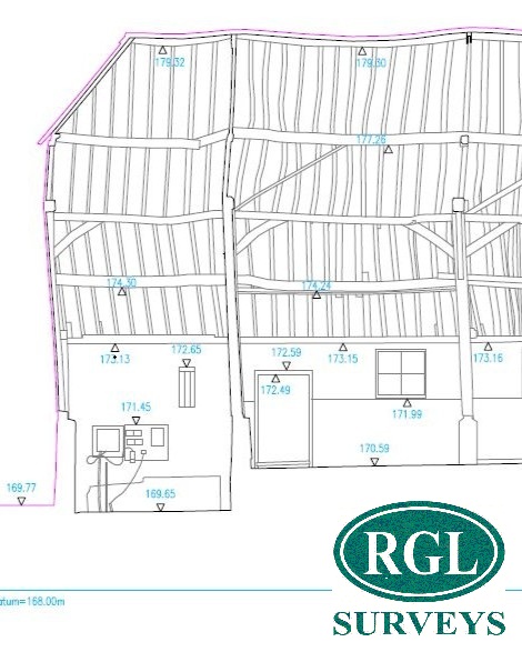
You should also confirm what site features must be captured. Typical requirements include boundaries, fences, walls, building footprints, changes in surface material, spot levels, kerbs, road markings, drainage assets, street furniture, overhead features and significant vegetation. That said, it depends on the site. A rural development plot may need ditch profiles, embankments and tree positions. An urban commercial site may need a more intensive record of service covers, façade lines, access points and confined level changes.
Information to provide before the survey starts
A surveyor can work more efficiently when the instruction includes practical project information rather than a one-line request for a quote. The most useful briefing material is usually straightforward.
Send the site address, a marked-up plan showing the required extent, known access arrangements, any health and safety requirements, and your preferred output format. If there is a planning drawing, utility sketch, existing layout or engineer’s mark-up, include it. If there are programme pressures, state them clearly.
This is also the stage to flag known site constraints. These may include restricted working hours, live traffic, occupied premises, rail interface, watercourses, heavy vegetation, security procedures or permit requirements. None of these are unusual, but they do affect planning, resourcing and price.
If the site has hidden complexity, say so. A modest site area can still require a detailed survey if levels are irregular, access is poor or adjacent features are critical to the design.
Check whether other surveys are needed alongside it
A topographic survey is often commissioned as a standalone service when the project would benefit from a coordinated scope. Depending on the site and the design stage, you may also need measured building information, utility detection, floor plans, building elevations, monitoring or volume calculations.
This is where procurement decisions can either simplify or complicate the project. If the design team will need external site data and measured building data to align, commissioning them together can improve coordination and reduce duplicated attendance. The same applies where utility information is materially important to excavation risk or drainage design.
It depends on programme and budget, but joined-up scoping often produces better project information than treating each requirement in isolation.
Choosing the right surveyor
Price will always be part of the decision, but it should not be the only one. A low fee can become expensive if the survey is incomplete, difficult to use or requires return visits. For commercial and technical projects, capability, responsiveness and output quality are usually the deciding factors.
Look for a surveying company with experience across different site types and project scales. The practical question is whether they can deliver accurate data in the conditions your project presents. That may involve congested urban settings, difficult terrain, live construction environments or complex coordination requirements.
You should also consider how the company manages communication. A dependable survey partner will ask sensible questions at instruction stage, confirm the scope in writing and explain any limitations before starting work. That process matters because it reduces ambiguity for everyone downstream.
For clients operating across London, the Home Counties, East Anglia or the Midlands, consistent delivery across different locations can also be important, particularly where portfolios or phased projects require a repeatable standard of output.
Agree timescales and constraints upfront
Survey programmes are often tied to wider design and planning deadlines, so realistic timescales need to be agreed early. That includes not only the site visit date but also delivery of processed drawings and any final checked outputs.
If there is a hard submission deadline, state it at the point of enquiry. If access is only available on certain days, mention that too. A technically straightforward survey can still be delayed by permit issues, occupied areas, weather exposure or third-party access permissions.
It is also worth asking what assumptions the quotation is based on. For example, does it assume clear visibility across the site, unrestricted access and no need for traffic management? These details can affect both timing and commercial clarity.
What a good instruction should cover
A well-commissioned survey instruction does not need to be lengthy, but it should remove uncertainty. In practice, a strong brief will confirm the site extent, purpose of the survey, required detail, preferred outputs, access arrangements, programme expectations and any known constraints.
It should also give the surveyor enough context to challenge gaps in the brief. That is often where value is added. Experienced survey teams will identify where extra coverage, different control requirements or complementary survey services may prevent issues later.
This is particularly relevant on sites where the project team is still refining the design. If there is uncertainty around boundaries, levels, adjoining infrastructure or access interfaces, say so. It is better to discuss those issues before mobilisation than after a design team has started working from incomplete information.
Avoiding common commissioning mistakes
Most problems come back to assumptions. The client assumes the surveyor will know what the design team needs. The surveyor assumes the marked-up plan reflects the full area of interest. The consultant assumes the delivered file will include a particular coordinate system or level datum. None of these assumptions are safe.
Another common issue is waiting too long. If a topographic survey is treated as a late procurement item, design work may start using outdated mapping, partial dimensions or estimated levels. That can work for a few days, but not for long. Once layouts, thresholds, drainage runs or cut-and-fill decisions are involved, reliable measured data becomes essential.
Good commissioning is therefore less about paperwork and more about clarity. The better the brief, the more useful the survey. The more useful the survey, the fewer downstream corrections the project team has to absorb.
A topographic survey should give your team confidence in the site information they are designing and building from. If the instruction is handled carefully at the start, the survey becomes a working foundation for the project rather than another issue to resolve later.